Places That Have Used VCAPS
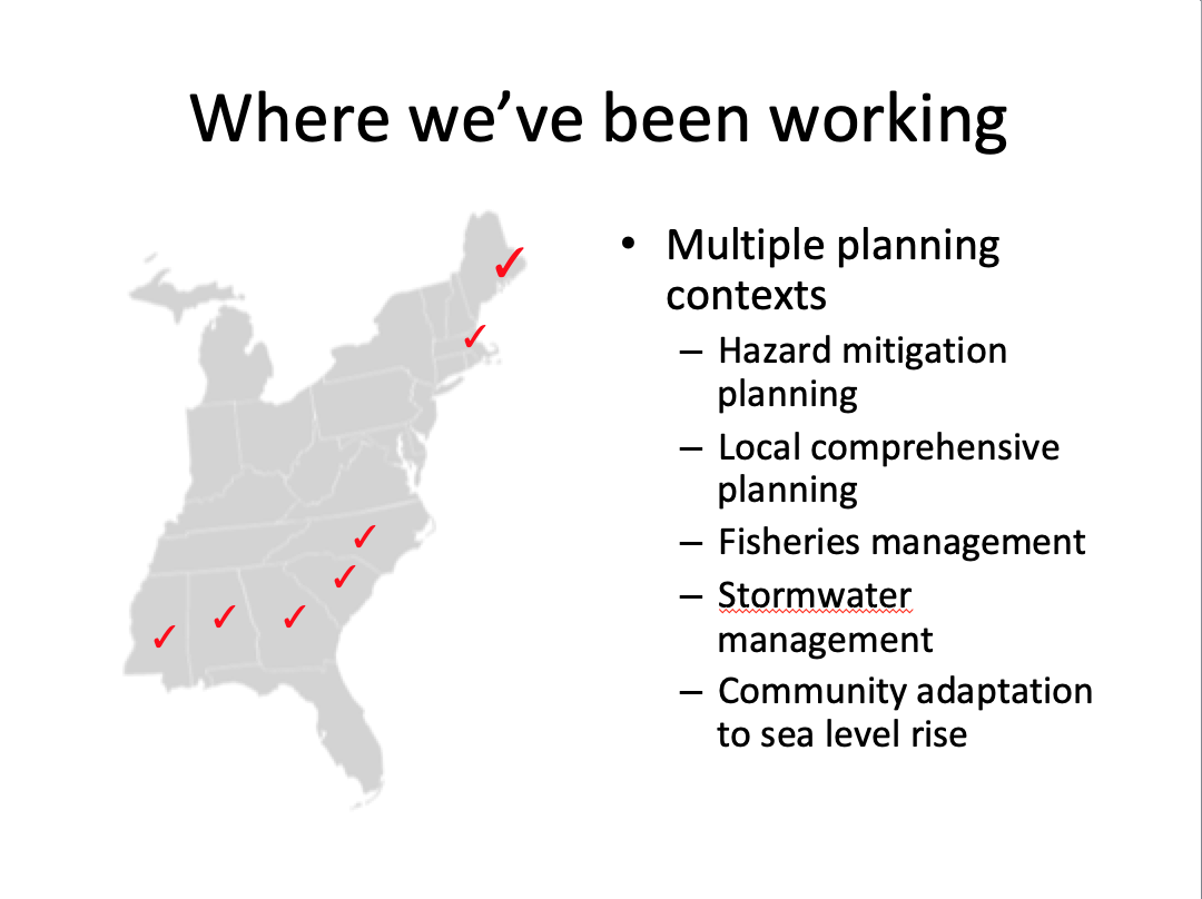
Alabama
Dauphin Island. Town officials in Dauphin Island, with funding from the Mobile Bay National Estuary Program, hosted a workshop using VCAPS on 5 December 2012, to discuss the impacts of extreme weather events, and especially flooding, erosion, and littoral shifts associated with storm surges, Like most communities along the Gulf coast, the barrier island of Dauphin Island, Alabama has repeatedly experienced extreme weather events, including hurricanes. Dauphin Island sits at low elevation and faces multiple impacts from storms. Its topography creates two distinct areas, the West End and the East End. The West End, essentially a long, narrow, and flat open beach is particularly vulnerable to overwashing during storms. Flooding from storm surges has caused significant damage. Wind associated with severe storms and hurricanes has also taken its toll. The City has engaged in planning activities, such as hazard mitigation planning, to develop strategic approaches to mitigating such impacts in the future. Expectations are that there will be increased exposure to extreme weather in years to come. The purpose of the VCAPS workshop was to develop a common understanding of potential impacts from climate change and continue discussions about how the town might respond. A report of the Dauphin Island experience is available. The results of the VCAPS workshop helped to inform a climate resilience study for Dauphin Island.
Orange Beach. To better understand and mitigate the impacts of extreme weather events and especially flooding from severe rainfall and coastal storms, city officials in Orange Beach organized a workshop using VCAPS on 14 June 2012. Funding for this workshop was supported by Mississippi and Alabama Sea Grant. Expectations are that there will face increased exposure to extreme weather in years to come, and in particular hurricanes and coastal storms associated with storm surges. Situated on the Gulf of Mexico and bordered on the north by the Intercoastal Waterway, the City sits at low elevations and faces many impacts from storms. Flooding is already a major problem and it is likely to get worse. The City faces challenges in preparing for hurricanes and in mitigating the impacts of storms. In addition, extreme heat events are projected to become more frequent. The purpose of the VCAPS workshop was to identify strategies for the city to manage the impacts from climate change. The group also discussed recovery from severe storms. A result of the workshop was a decision to develop a program to provide more information to evacuated residents in the aftermath of a storm in ways that would facilitate more rapid return and recovery of residents. A report describing the VCAPS process in Orange Beach is available.
Colorado
Carbondale. Carbondale is a mountain town on Colorado’s Western Slope. In the past the Town has suffered from drought and in 2018 experienced one of the most severe droughts to date. The town has put into place water conservation measures to try and mitigate the impacts of drought. Nevertheless, with a growing population and likely higher drought frequency in the future, the Town has a growing interest in climate resiliency and integrating an understanding of projected impacts of climate change into town planning and operations. On September 26-27, 2018, the Town of Carbondale participated in a Vulnerability, Consequences, and Adaptation Planning Scenarios (VCAPS) workshop, organized by Western Water Assessment (WWA), with a focus on drought and nine themes: 1) reduced runoff, 2) stress on ecosystems, 3) fires, 4) reduced water supply, 5) more concentrated solids in waste water, 6) tourism, 7) reduced irrigation for town facilities, 8) reduced water for agricultural irrigation out of town, and 9) call on the Nettle Creek. The full report is available here.
Cortez. Cortez, in Montezuma County, experiences regular droughts and in 2018 experienced its most severe drought since 2002. The economy in Cortez is heavily dependent on tourism, with Mesa Verde National Park being a significant draw, and Montezuma County is dependent on agriculture. Both industries are vulnerable to drought impacts. The City of Cortez participated in the Vulnerability, Consequences, and Adaptation Planning Scenarios (VCAPS) workshop, organized by Western Water Assessment (WWA). The full report is available here.
Georgia
St. Marys. St. Marys is one of the most vulnerable cities in Georgia to anticipated coastal changes, such as increased coastal flooding, rising seas and intensified storm surges. In 2013, the community was selected through a nationwide NOAA Sea Grant funding competition as one of five locations in the United States to undergo community resilience and adaptation planning. This project is a collaboration between St. Marys and Georgia Sea Grant, North Carolina Sea Grant, Stetson University and the University of Georgia. VCAPS was used to gather and organize information from decision-makers, departmental staff and key stakeholders that are directly involved with planning and carrying out responses in the event of natural disasters. A Flood Resiliency Plan is being created by combining academic expertise with the insights and experiences of those working and living in St. Marys. For more information about this project, visit the Georgia Sea Grant website.
Tybee Island. Coastal storms and sea level rise threaten Tybee Island, low-lying a barrier island off the coast of Georgia. Property and infrastructure are vulnerable to flooding. Furthermore, Tybee Island's only road linkage to the mainland Savannah Metropolitan area is provided by US Highway 80. Sections of this highway are very low-lying and currently flood approximately 4-5 times each year during spring tide events. Over the next several decades the frequency of road flood events is expected to increase significantly due to sea level rise if the road is maintained at its current elevation grade. Georgia Sea Grant and the University of Georgia's Carl Vinson Institute Of Government were awarded a grant from NOAA's National Sea Grant Program Coastal Communities Climate Adaptation Initiative (CCCAI) in 2012 to support the development of a climate adaptation plan for the Island. The recommendations developed by the project are intended to help the City prepare for and adapt to sea level rise through appropriate local ordinances, infrastructural improvements and other municipal actions. VCAPS was used as part of public meetings to gather and organize information about the impacts of multiple sea level rise scenarios. This information was used to inform the identification of adaptation options. For more information about this project, visit the Georgia Sea Grant website.
Hawaii
West Kaua’i. A team from UH Sea Grant and the Department of Urban and Regional Planning used VCAPS as part of the West Kauaʻi Community Vulnerability Assessment in 2018. An important outcome of the West Kauaʻi CVA process was the information it provided for the update of the West Kauaʻi Community Plan, a planning tool used by the County of Kauaʻi to guide development and the protection of resources. This vulnerability assessment presents profiles of assets, facilities, and resources identified by the community as management concerns describing their vulnerability to three primary coastal hazards: (1) coastal erosion; (2) passive flooding; and (3) annual high wave flooding. The management concerns include transportation and evacuation, drainage, beaches and coastal properties, cultural resources, agriculture, and critical infrastructure, including levees, wastewater, water, and electricity. The outcomes from the West Kauaʻi CVA are being used to inform the next steps of the climate change adaptation process. For more information about this project, visit the Hawaii Sea Grant website and a website with the report.
Maine
South Thomaston. We employed VCAPS with a group of lobstermen and community leaders in this small municipality in mid-coast Maine to characterize how climate change was impacting the lobster fishery and the community and to identify resilience actions they could take. Based on this project, funded by the NOAA COCA program, it is clear that lobstermen are seeing significant changes in their environment and are seeking ways to respond to these changes in policy and in how they fish. They are eager for data and knowledge. During the VCAPS process in Maine, some lobstermen advocated adaptation actions such as reducing fishing effort in the early summer when the lobster is of low economic value. During our facilitated discussions the lobstermen realized that they needed to better understand the complex connections between fishing effort, timing of lobster molting, and the price of lobster. We used STELLA system dynamics modeling software to characterize some of these connections, using available data and science. The model lets participants run scenarios that characterize the output of different resilience action strategies. We met with individual lobstermen to calibrate the model to their specific experience and to explore impacts of changing fishing effort on their bottom line. We then presented the model and its simulations back to the community in three workshops/meetings. Reports developed as part of the project include an overview of the project, a poster presentation, and a report describing (1) the geographical context of South Thomaston and Spruce Head at multiple scales; (2) the different ways in which fishermen and scientists monitor and model processes of environmental change; and (3) scenarios and opportunities associated with climate change that were discussed during VCAPS meetings.
Massachusetts
Boston. Boston began updating the City's hazard mitigation plan (HMP) in 2010. Hazard mitigation plans are typically revised every 5 years. Normally the HMP is based on past events and trends to forecast future impacts. For this revision of the HMP the City decided it was important to consider projected increases in the severity of storms, sea level rise, and heat due to global climate change. From January through May 2012, the Social and Environmental Research Institute (SERI), with funding from MIT Sea Grant, facilitated five meetings using VCAPS to discuss the implications of climate change for weather-related hazards in Boston. We focused discussions on three focusing on three weather related hazards: flooding from precipitation and storm surges, winter storms, and extreme heat. To make meeting size reasonable and still involve a cross-section of City employees at each meeting, we organized five meetings around the following themes: water and sewer, infrastructure, regulatory, building and facilities, and public safety. The first meeting was largely among members of the Boston Water and Sewer Commission, but the subsequent meetings involved representatives from numerous government agencies and private groups, such as: Ground Water Trust, Homeless Services Bureau, Environment Department, Historic Preservation, Housing Authority, Boston Public Health Com-mission, Massachusetts Water Resource Authority, Northeast States Emergency Consortium, Coastal Zone Management, Massport–Logan IAP, Inspectional Services, Boston Public Library, Northeast Document Conservation Center, Massachusetts Board of Library Commissioners, University of Massachusetts Boston, Department of Neighborhood Development, Police and Fire Departments, among others. Information from the VCAPS report for Boston was integrated into the Hazard Mitigation Plan (Appendix B) for Boston completed in December 2012.
New Bedford and Fairhaven. To better understand and mitigate the impacts of extreme weather events and especially flooding from severe rainfall and coastal storms, city officials in New Bedford and Fairhaven organized two VCAPS workshops on 2 and 11 October 2012. New Bedford and Fairhaven, Massachusetts, have experienced extreme weather events, including severe coastal storms. Expectations are that they will face increased exposure to extreme weather in years to come from changes in the climate that will have a profound effect on the economy, public health, coastal resources, natural features, water systems, and infrastructure. Situated on the south coast of Massachusetts in Buzzards Bay, the New Bedford and Fairhaven share a narrow bay at the mouth of the Acushnet River. This location renders them vulnerable to severe coastal storms. The presence of a large hurricane barrier spanning the harbor provides some protection against storm surge, but does not prevent frequent flooding. Flooding has been a major problem. Both communities face challenges in preparing for severe coastal storms, including hurricanes, and in mitigating the impacts of storms. In addition, extreme heat events are projected to become more frequent. A report describing the VCAPS process with Fairhaven and New Bedford is available.
Plymouth. Plymouth, Massachusetts, was revising its Hazard Mitigation Plan during 2011. Flooding, storm surges, and shoreline erosion routinely have negative impacts on the community. Such events complicate existing management and planning challenges. On 10 and 17 November 2011, six members of Plymouth's management boards and committees used VCAPS to begin the process of revising the Hazard Mitigation Plan. The group focused on two challenges. The first was the problem of flooding as a combined result of sea level rise and increased precipitation. The second was coastal erosion as a result of stronger and more frequent storm events. Both of these hazards can lead to serious consequences for the Town. A report describing the VCAPS process in Plymouth, Massachusetts, is available.
Wellfleet. The history of the Town of Wellfleet is closely connected to shellfish in Wellfleet Harbor. Shellfish, including oysters, quahogs, and scallops, are key drivers of the town’s economy and identity. Commercial shellfishing, from aquaculture and wild populations, provide jobs, tax revenues, and income to local residents. Recreational shellfishing has many participants, forming an important social activity among residents and tourists. Shellfish also filter large amounts of water, and healthy populations improve water quality in the Harbor which is impacted by stormwater and wastewater runoff. Oyster reefs reduce erosion and the impact of storm surge and wave action. Climate change may impact shellfish populations and health and the shellfishery in multiple ways. At the same time, shellfish can promote resilience in the face of climate change. Large, healthy populations of shellfish have more resiliency, provide more buffering from acidic waters, improve water quality, and reduce erosion from storms. A working group on Climate Change Impacts on Shellfishing in Wellfleet Harbor began meeting in the fall of 2013 and is using the VCAPS process combined with systems dynamics modeling to identify: threats to shellfishing in Wellfleet Harbor from climate change, the role of shellfish in mitigating impacts from climate change and other environmental hazards in Wellfleet Harbor, and strategies to increase the resilience of Wellfleet and its shellfishery in a time of climate change. A brief overview of this project is available. Reports summarizing the impacts of climate change on shellfish and shellfishing, sea level rise on aquaculture, and strategies to manage to increasing risks of Vibrio infections from rising air and water temperatures were produced as part of this project and can be found on the website Planning for Climate Change Impacts on Shellfish in Wellfleet Harbor.
North Carolina
Hyde County Georgia Sea Grant, North Carolina Sea Grant, the University of Georgia’s Carl Vinson Institute of Government and UGA Marine Extension Service are partnering with Hyde County, NC to develop a community resilience and adaptation plan. Hyde County is at risk to coastal flooding from climate change and variability, including extreme rainfall events and future sea-level rise. VCAPS is being used in a series of public workshops to develop detailed assessments of communities’ current and future vulnerabilities. For more information about this project, visit the Georgia Sea Grant website.
Plymouth. As part of a more extended planning effort supported by North Carolina Sea Grant, the town of Plymouth, North Carolina, participated in a VCAPS process. On 4 and 5 October 2011, seven community leaders and managers met for two meetings. Those invited to participate in the meeting had some degree of decision-making responsibility in the town related to the issues and included the mayor, town board members, the utility director, the county emergency management director, the town engineer (consultant), the police chief, the county soil and water conservation district manager, and a representative from a local water association. Although the group originally envisioned doing separate diagrams for stormwater and wastewater infrastructure, further discussion revealed that grouping both of these issues under the "stormwater" management umbrella was logical, as they are tied together by the many causes of flooding in Plymouth. Together, the Plymouth participants identified potential outcomes and consequences of continued drainage system deterioration combined with water level rise. Discussions also centered on possible responses by the Town and individual residents, including "no regret" strategies, which offer immediate benefits whether or not projected changes in water levels occur, and "low regret" strategies, which present tradeoffs between greater future security and some limited current costs and benefits. The group considered possible consequences associated with various management approaches. A report is available from North Carolina Sea Grant. Additional information is available from the Carolinas Integrated Sciences and Assessments Program.
South Carolina
Beaufort County (climate adaptation planning). Beaufort has the distinction of being the first county government to use the VCAPS process. Located at the heart of the Lowcountry, Beaufort’s geography includes barrier islands separated by wide expanses of marshland with occasional upland bluffs created by ancient dune systems. Over two-thirds of the County uplands are within the special flood hazard zone. Recognizing their potential vulnerability, the 2010 Beaufort County Comprehensive Plan calls on the government to help anticipate and plan for sea level rise. With National Sea Grant funding, the South Carolina Sea Grant Consortium, the Social and Environmental Research Institute (SERI), the Carolinas Integrated Sciences and Assessments (CISA) program at the University of South Carolina, and North Carolina Sea Grant partnered to assist the Beaufort County Planning Department in beginning the process of adaptation to sea level rise. The team used the VCAPS method to guide a mixed group of 19 elected officials, local government staff, and civic leaders through group discussions about how sea level rise, storm surge, and precipitation change could affect the County and what actions the County could take to adapt. These diagramming meetings were conducted in August 2013. During follow-up meetings through 2014, the project team mapped the potential impact of sea level rise using data from the National Oceanic and Atmospheric Administration and conducted additional research. In August 2014, the project team hosted public workshops to obtain input and additional ideas from the broader public. In May 2015, the team released the Final Report and Executive Summary, which include 23 adaptation actions for the County to consider in planning and implementation.
Beaufort County (Blue Crab fisheries management). Blue crabs comprise an extremely valuable fishery in the Southeast U.S. However, since the mid-1990's blue crab landings in this region have declined dramatically, causing concern over the health of blue crab populations and sparking efforts to better understand environmental impacts on this species. The decrease in blue crab landings has been correlated with increased salinities in estuarine and river waters during periods of drought. SERI, the Carolinas Integrated Sciences and Assessments Program at the University of South Carolina, and the South Carolina Sea Grant Consortium have been working with crabbers, scientists, and local resource managers in Beaufort County, SC, to better understand how they see the challenges a changing climate pose to the community and the local blue crab fishery and what steps might be taken to address those challenges. The project team used the VCAPS process to facilitate this dialogue and identify key data gaps. This interaction has led to the creation of the Crabbers Who Care Research Network that will help fill data poor areas of an ecosystem-based business management tool. Tools and discussion generated by this NOAA Coastal and Ocean Climate Applications Program-funded project will help fishermen on an individual business management level while also fostering communication about climate-related changes in fisheries and fishery-related policy.
McClellanville. The low elevation and flat topography of South Carolina's Low country mean that many environmental hazards, such as flooding, erosion, hurricanes, tidal surges, and shoreline erosion routinely have negative impacts on its coastal communities. Such events complicate existing management and planning challenges facing coastal communities like McClellanville. On 31 March and 1 April 2011, six members of McClellanville's management boards and committees met to begin addressing some of these issues in their community using the VCAPS process. Discussions focused on stormwater and drainage management, including issues related to flooding, standing water, soil saturation, increased pollution loads, and sea level rise. A diagram of their process and the report on stormwater management are available.
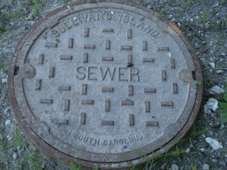
Sullivan's Island. Barrier island communities, like the Town of Sullivan's Island, South Carolina, routinely face many environmental hazards such as flooding, erosion, hurricanes, tidal surges, and shoreline erosion. Interactions among these events coupled with potential impacts from climate change complicate existing management challenges and planning efforts. To better understand and mitigate the impacts of extreme weather events and especially flooding from severe rainfall and coastal storms, a series of four two-hour meetings were held with participants from the Town of Sullivan's Island and the University of South Carolina, South Carolina Sea Grant Extension, and the Social and Environmental Research Institute to identify current management challenges that may be intensified by climate changes and to identify what strategies and actions the Town can consider to improve long-term planning efforts. Meetings centered on understanding major management considerations for Sullivan's Island associated with increase in the number of extreme rainfall, sea level rise and higher high tides. A report summarizing the major points identified in these meetings is available. A journal article describing the process and outcomes was published in 2014.
 VCAPS can’t proscribe something for every community but it can stimulate the thought that needs to go into each community looking towards coming up with strategies for SLR and increased storm frequency. Every community is different and has strengths and weaknesses.